Property age information is necessary when taking out building insurance. More than 15% of properties in England were built before 1900, whilst the ones built before 1965 account for more than 50% (Valuation Office Agency, 2023). Knowing the age at which the property was built makes it easier to assess contamination liability and ground stability issues. If the property's location has been used solely for residential purposes for a long time, there is a lower risk that the land is contaminated by industrial pollutants. Additionally, properties constructed before 1950 are generally considered to be at low risk for ground stability issues related to coal mining, as the locations of mines were better documented during their construction compared to later periods.
So, how can we search for property age? HM Land Registry (HMLR) suggests obtaining a copy of the title register or referring to the registered information of historic buildings in the National Heritage List for England (HMLR, 2018). Although there are various means to find out the property age, obtaining it for many properties in a broad area can be tedious and costly. Thankfully, historical maps are abundantly available across the UK enabling us to track neighbourhood changes over decades. The Ordnance Survey's historical maps are a valuable source of information for identifying the ages of properties.
This projectexplored the potential of the automated property age estimation approach, leveraging historical maps (outside copyright) from the mid-late 19th and early 20th centuries. A proof-of-concept has been carried out for a suburban area of Leeds, specifically Headingley.
The approach taken was to compare the current property outlines with those extracted from historical maps from different years and identify the year the building first appeared.
The workflow was composed of the following steps.
- Training the deep learning model (Mask R-CNN) to recognise various building symbols.
- Extracting property outlines from historical maps, accounting for different map scales and symbologies.
- Validating the results by comparing current building outlines with those extracted from historical maps.
- Image analysis with the deep learning model was applied to building outlines. The model was trained with a subset of historical maps so that the model could recognise the target map symbology. The principle of transfer learning was applied, which customises an existing model to minimise the required data and time for training whilst utilising the model's general inference performance (Marmanis et al., 2016).
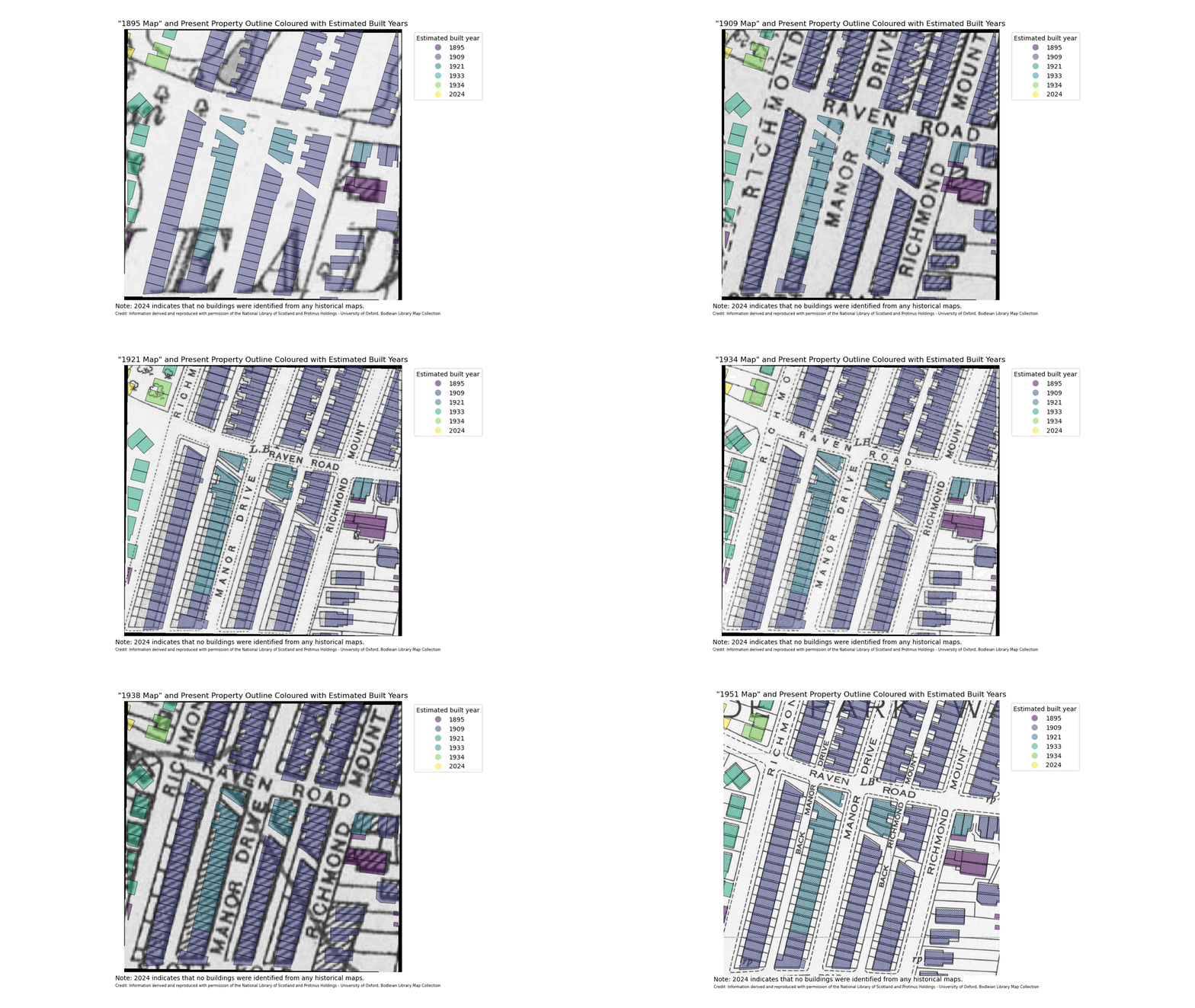
The built years of the properties were successfully identified in the study area, as illustrated in Figure 1. The animation shows how the estimated built years match the year the property first appears on the map.
 Figure 1 - Historical Maps from Different Years and Present Property Outlines with Estimated Built Years
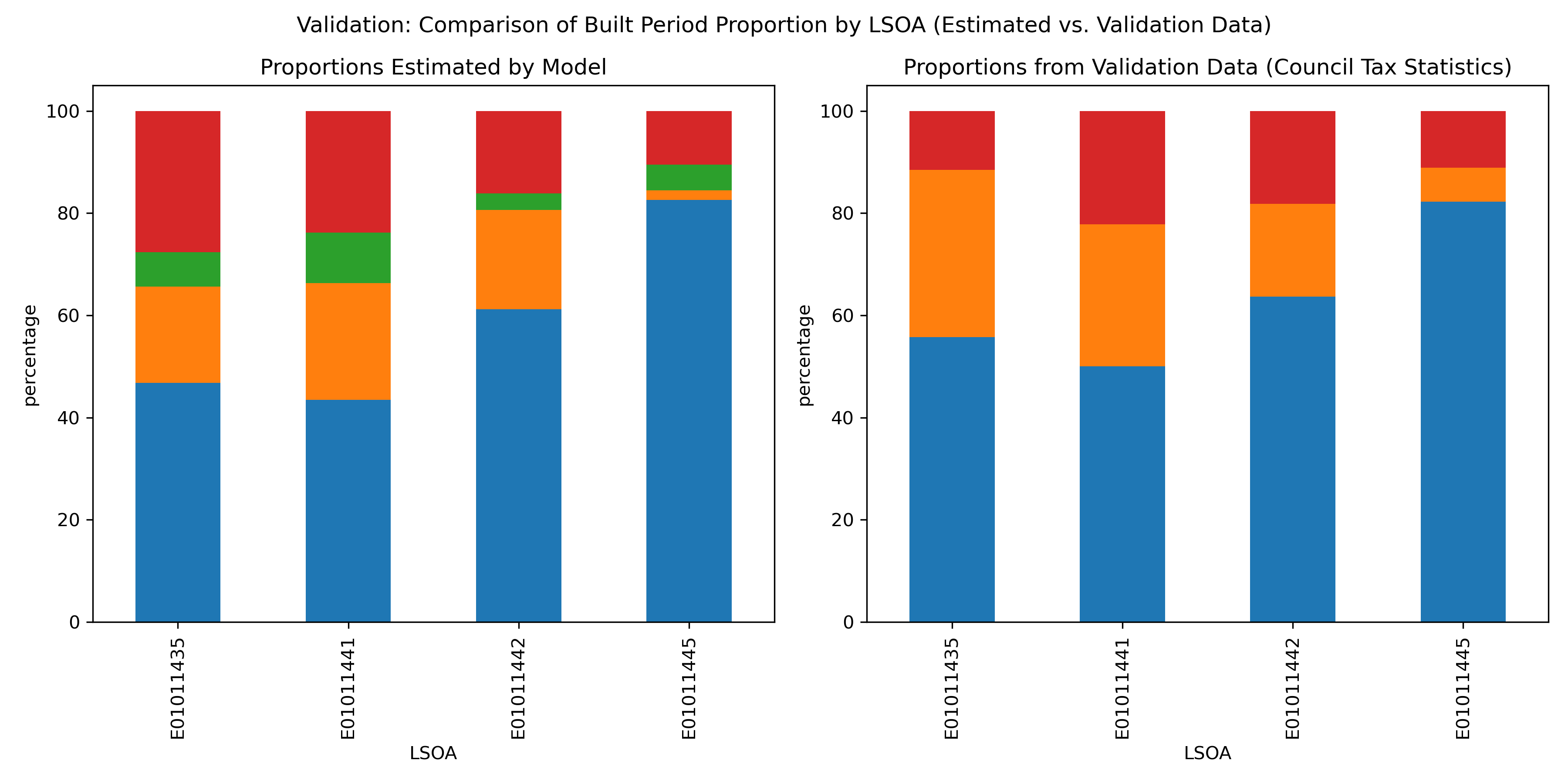
Finally, the results were validated with actual property age data from “Council Tax Statistics 2023”, which offers an aggregated dataset grouped by geographic areas called Lower layer Super Output Areas (LSOAs). Among the four LSOAs which cover the study area, two LSOAs exhibited distributions of built periods that were not significantly different from the actual data, proving the high accuracy of the estimations. The other two LSOAs showed significant differences between the estimated and validation data distributions. The discrepancy is mainly attributed to two factors:
1) inconsistent data coverages and,
2) failures in image analysis caused by building symbols that the model was not trained to recognise.
The maps use different symbols for buildings based on the roof type and extensions. The deep learning model used in the image analysis overlooked buildings represented by a specific symbol, which led to the misidentification of the built years. Additional model training on these symbols would improve the estimation . In addition, whilst this project employed techniques to identify the same properties across maps from different years, the identifications can be inaccurate when a property has been replaced by a new one at the same location.
 Figure 2 - Model-estimated and Actual Proportions of Properties’ Built Periods by LSOA
This approach excels at the following points:
- It can estimate more specific ages (built years) of properties.
- It can instantly estimate the property ages in a broad area.
- It can be applied to other cities in the UK with minimum adjustments, as historical maps are widely available nationwide and use the same building symbols.
- It can be customised with additional training on the deep learning model for estimating property ages in cities outside the UK.
This innovative approach revolutionises the tedious estimation process and enables the instant provision of property age information to enhance Martello Environment Searches. Whilst this study made use of out-of-copyright historical maps, the approach can be applied to cover the full temporal spectrum from the industrial revolution through to present day.
References:
- HM Land Registry. 2018. How old is my house?. [Online]. [Accessed 24 July 2024]. Available from: https://hmlandregistry.blog.gov.uk/2018/01/26/how-old-is-my-house/
- Marmanis, D., Datcu, M., Esch, T. and Stilla, U. 2016. Deep Learning Earth Observation Classification Using ImageNet Pretrained Networks. IEEE Geoscience and Remote Sensing Letters. 13(1). pp.105-109.
- National Library of Scotland and Bodleian Library. 2024. Ordnance Survey Map. National Library of Scotland and Bodleian Library.
- Ordnance Survey Limited. 2024. OS Mastermap Topography Layer. Ordnance Survey Limited.
- Valuation Office Agency. 2023. Council Tax: stock of properties, 2023. Valuation Office Agency. [Online]. [Accessed 30 June 2024.]. Available from: https://www.gov.uk/government/statistics/council-tax-stock-of-properties-2023